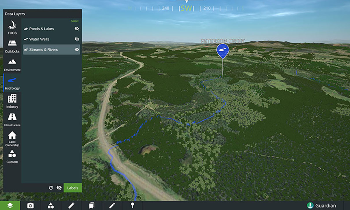
Guardian collects complex landscape-level data to create a virtual twin for First Nations
Seeing is believing. Raw numbers have their power as an objective metric of change, but being shown that change with our own eyes is what really leaves a mark.
That’s the philosophy behind Guardian, a new data preservation and land management software platform from Victoria-based spatial intelligence provider LlamaZoo. After a year of collaboration with First Nations around B.C., this tool was designed for the use and benefit of Indigenous communities.
Aggregating landscape-level data from sources like satellites, drones and environmental assessment programs conducted by surveyors, geologists and engineers, Guardian makes the information more readily and easily accessible.
“We can understand so much more from visualization than we can from charting graphs and tables and documents,” says LlamaZoo co-founder and CEO Charles Lavigne. “It’s the most powerful communication tool we have available to us. I can show you a picture, and it’s worth a thousand words. Well, what if I could take you somewhere virtually? You can see the impact of a project, or you can see the cultural history of the land through video and audio and photos embedded in the land that tell the stories of how the land was used and its meaning today, and why it’s important for a particular community or First Nation to not disturb an area of a land.”
Like a more detailed version of Google Earth, Guardian creates a virtual twin of landscapes that Indigenous leaders can use to preserve and manage their land. Most people can start deriving value from the data within five minutes, Lavigne says. “If we think of knowledge as power, we’re putting that power in the hands of many more stakeholders and participants.”
In addition to uses ranging from carbon credit mapping to land planning, this stewardship tool helps to assess wildfire risks, map culturally significant sites, improve internet connectivity to remote regions and more.
Guardian, already in use by 15 First Nations around B.C., can create transparency with the community and support meaningful conversations between chief and council. “Preserving our culture, land, water sources and ancestral knowledge is very special to us,” Robin Billy, director of operations with the Stk’emlúpsemc te Secwépemc First Nation, said in a release. “This technology supports that preservation while facilitating meaningful conversation. For our people, it’s also critical in passing this knowledge along to younger generations. That has been brought to life using the 3D virtual reality experiences that Guardian can provide.”